preloader-image

CHIAMA+39 347 0675286
V.le G Berto snc89866 Ricadi
CHIAMA+39 347 0675286
V.le G Berto snc89866 Ricadi

01

Hydrogeology

The hydrogeological structure of a territory defines the complex dynamics of surface and ground waters and their interactions with soil and rocky slopes. ....

02

Environmental Geology

Aspects and interactions between human, ecosystem and eartH....

03

Territory Planning

Sustainable development and environmental protection...

04

Geotechnical engineering

Geophysics for civil engineering works ...

01

Hydrogeology

The hydrogeological structure of a territory defines the complex dynamics of surface and ground waters and their interactions with soil and rocky slopes...

02

Environmental Geology

Aspects and interactions between human, ecosystem and earth...

03

Territory Planning

Sustainable development and environmental protection...

04

Geotechnical engineering

Geophysics for civil engineering works ...

GEOLOGIST TECNICO GEOLOGICO

The geologist Francesco Taccone is in the Register of Geologists of Calabria registered. 

The geologist Francesco Taccone is in the Register of Geologists of Calabria registered. He deals with geology, geotechnical and seismic hazard of buildings, territorial geology, environmental characterization and hydrogeological studies.

He has extensive experience in the planning and construction of wells, in water research and in the hydrogeological, ecological and geological characterization of waterways.

He takes care of the sampling or continuous monitoring of water sources (wells, springs), conducts hydrogeochemical assessments of water quality and examines the relationship between water and rocks to meet customer needs best.

Based on the experience, expertise, organization, constant updating and careful selection of technologies evaluated by the market and latest study, as well as calculation and measurement methods, the most technically and economically feasible solutions are proposed for each situation.

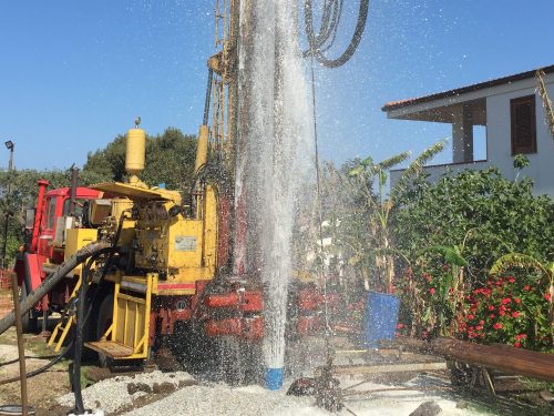
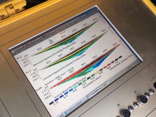
The Company has equipment for geophysical and geophysical field surveys: geoelectric and seismic refraction tomographies, MASW, microquake registration, HVSR and penetration records.

He is able to provide answers and advanced solutions in areas such as geophysical and geotechnical investigations, pollution site characterization and seismic risk assessment.

Skills And Service

Specific skills and tools to provide consulting, services and services in collaboration with: :

Hydrogeological investigations of the porous groundwater system (soils) and cracks (rocks)
Efficiency and productivity studies of wells and wells
Planning and consulting of wells and springs
Evaluation of hydrogeological parameters (surface and bore permeability tests, pump tests, etc.)
Design of partial closures, full closures and the final safety of wells and springs
Application for concession and technical reports for wells, wells and surface derivations
Technical reports and advice for discharge permits (soil, subsoil and surface water bodies)
Integrated water balance and hydrogeological balance
Management and optimization of the use of water resources (wells and sources, surface drainage)
Planning maintenance and restoration of wells and wells
Planning, organization and management of geotechnical and geologic surveys
Dynamic and static penetration tests
Geologic measurements and piezometers
Sampling, classification and preservation (environmental and geotechnical)
Laboratory investigations (environment and geotechnical engineering), seismic refraction
Stratigraphy of superficial deposits in small and medium depths
Trend and depth of the rocky ground
Reflection seismic
Stratigraphy of superficial deposits in small, medium and large depths
Trend and depth of the rocky ground
Release surfaces in case of landslides
Evaluation of deposits and thicknesses of gravel / sand / clay for quarrying
Borehole - cross hole - seismic tomography
Detailed stratigraphy on a small scale
Determination of dynamic elastic parameters of soils and / or rocks
Detailed 2D sections
Vertical electrical measurements
Assessment of the layer depth or the impermeable substrate
Assessment of potential water level and groundwater depth
Stratigraphy of superficial deposits in small, medium and large depths
Detection of salt intrusions in the coastal layer
Evaluation of the specific resistances for the positioning of earth connections
Electric tomography
Detailed studies at shallow depths to identify pollutant diffusion areas
2D resistance sections

TESTIMONIALS

Servizio impeccabile che ha concesso alla mia azienda di realizzare un pozzo di irrigazione minimizzando i costi grazie alla precisione di intervento.

Antonio M,

CONTACT

Contact us.

Telephone!

Direct Contact:
+39 347 0675286
Address: 

Viale G. Berto, San Nicolò di Ricadi, 89866 Vibo Valentia – Italia

Email: 

info@studiotaccone.com

Social: 
Opening Time:
Lunedì
8:00 - 20:00
Martedì
8:00 - 20:00
Mercoledì
8:00 - 20:00
Giovedì
8:00 - 20:00
Venerdì
8:00 - 20:00
Sabato
8:00 - 20:00